West Coast Region
Overview
The West Coast Regional Office of NOAA’s Office of National Marine Sanctuaries manages 19,876 square miles of marine protected areas around Channel Islands, Chumash Heritage, Cordell Bank, Greater Farallones, Monterey Bay and Olympic Coast. Each of the six national marine sanctuaries in the U.S. West Coast is a jewel unto itself. Yet each of our sanctuaries is intimately connected not only with the others, but also to the entire coast from Alaska to Baja and to the far reaches of the world ocean via ocean currents.
The West Coast Regional Office, like the two other regional offices (East Coast, and Pacific Islands), plays an important role in enhancing the Office of National Marine Sanctuary’s mission effectiveness, primarily through coordination and communication between headquarters and sites. They provide policy, operational, and day-to-day administrative support to the leadership and staff of all national marine sanctuaries or marine national monuments. These offices also address issues of broad regional concern and are responsible for assisting the director and deputy director in the administration of all regional resources and providing input to the administration as a whole. The regions also oversee the analyses and public processes required for designating a new sanctuary in their region.
The links on this page will take you on a tour of America’s West Coast sanctuaries where you will discover more exciting news about the work we do to keep our marine sanctuaries safe and thriving.
Designation of Chumash Heritage National Marine Sanctuary
The West Coast Region led the process for the 2024 designation of Chumash Heritage National Marine Sanctuary, an area encompassing approximately 4,543 square miles, along 116 miles of mainland coast, stretching from just south of Diablo Canyon Power Plant in San Luis Obispo County to Naples Reef on the Gaviota Coast in Santa Barbara County. The region’s lands and waters hold cultural, spiritual, and historical significance to coastal, ocean-going Indigenous Peoples that have resided here since time immemorial. Special geological features like Rodriguez Seamount create unique ecological conditions in the area. This, combined with an important biogeographic transition zone and upwelling, support large populations of marine life and boost both biodiversity and productivity. Over 200 shipwrecks are documented in the region, including the Gold Rush-era steamship Yankee Blade, which is listed on the National Register of Historic Places.
Due to threats to the area from human activities, industrial uses, and environmental shifts, additional protection and management is needed. Rather than focusing on a single species, issue, or activity, NOAA’s Office of National Marine Sanctuaries uses an ecosystem-based management approach that considers interactions among physical features, marine life, and human activities within the sanctuary environment.
The designation of Chumash Heritage National Marine Sanctuary brings comprehensive community- and ecosystem-based management to the area’s nationally-significant natural, historical, archaeological, and cultural resources, while meaningfully involving local Tribes and Indigenous groups, to help guide sanctuary management and programming.
West Coast Vessels
The West Coast Regional Office operates three research vessels on behalf of Cordell Bank, Greater Farallones and Monterey Bay national marine sanctuaries: its flagship, the 67 foot Fulmar and the newly acquired 22 foot Tegula. Additionally, the Fulmar is equipped with a 13 foot inflatable skiff, the R1306. The vessels are based in Monterey, but the Tegula can be trailered and easily deployed from a boat ramp. The vessels are specially designed to complete projects that fulfill the Office of National Marine Sanctuaries’ mission. They support a wide variety of missions and provide access to offshore sites and extensive stretches of the coastline that cannot be reached by land. Resource protection and management are at the core of the projects supported by the vessels, but education and outreach are also a priority for the vessels.
Olympic Coast National Marine Sanctuary operates the 52 foot Storm Petrel off the remote Olympic Peninsula. This newer vessel provides a greater opportunity to conduct research opportunities with a larger platform and bigger A-frame.
Channel Islands National Marine Sanctuary operates the 62 foot Shearwater and the 29 foot Minke to conduct research and diving operations around the Channel Islands.
Greater Farallones and Cordell Bank national marine sanctuaries acquired the 22 foot Hurricane from Olympic Coast National Marine Sanctuary to use for the vessel mooring program in Tomales Bay.
Sanctuary Advisory Councils
A sanctuary advisory council is a community-based organization of representatives from various user groups, local businesses, government agencies and the public at large. Advisory councils provide advice to their respective sanctuary superintendents on management of that particular sanctuary. Each west coast sanctuary has a sanctuary advisory council that meets at various times throughout the year and are open to the public.
Key Regional Documents
Management Plans
Management plans are site-specific documents that the Office of National Marine Sanctuaries uses to manage individual sanctuaries. Management plans:
- articulate visions, goals, objectives and priorities for an individual sanctuary;
- summarize existing programs and regulations;
- guide preparation of annual operating plans;
- guide management decision making;
- ensure public involvement in management processes; and
- contribute to attaining national system goals and objectives.
Terms of Designation
Terms of designation are the official documents that designate a sanctuary and defines why the sanctuary was designated and summarizes how it is to be managed. Terms of designation also provide background information about NOAA's regulations within the sanctuary. At the beginning of the document, one will find a "Response to Comments" section that describes NOAA's responses to public comment on a suite of issues during the sanctuary's designation.
Regulations
ONMS regulations prohibit specific kinds of activities, describe and define the boundaries of the designated national marine sanctuaries, and set up a system of permits to allow the conduct of certain types of activities (that would otherwise not be allowed). In general, regulations are used by the ONMS to implement the National Marine Sanctuaries Act and national marine sanctuary management plans. Each sanctuary has it's own set of regulations, as well as regulations that apply to the entire ONMS system.
Federal Register Notices
The Federal Register informs citizens of their rights and obligations and provides access to a wide range of federal benefits and opportunities for funding. The Federal Register is printed each business day and contains information on federal agency regulations, proposed rules and public notices, executive orders, proclamations and other presidential documents. A list, with web links, of the important Federal Register notices for the five west coast national marine sanctuaries has been provided in the consolidated management document.
Condition Reports
The National Marine Sanctuary Program Condition Reports provide a summary of resources in each sanctuary, pressures on those resources, the current condition and trends, and management responses to the pressures that threaten the integrity of the marine environment. Specifically, the reports include information on the status and trends of water quality, habitat, living resources and maritime archaeological resources and the human activities that affect them. View each sites respective Condition Report below or view the web-enabled condition reports that combine artwork with science information.
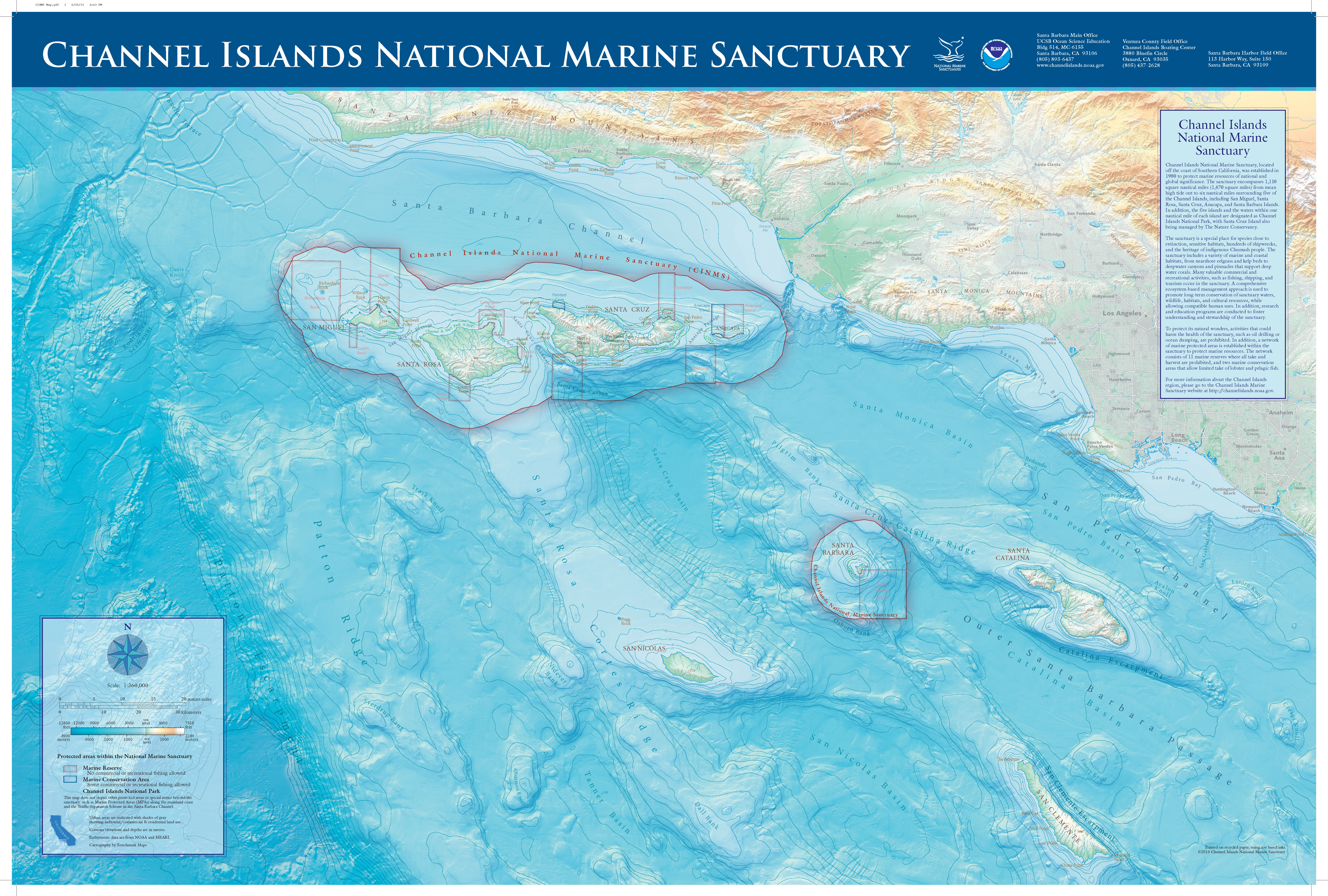
Channel Islands
Channel Islands National Marine Sanctuary contains spectacularly rich and diverse marine life. With a variety of habitats including kelp forests, sandy bottom, and open ocean, it is home to diverse fish and invertebrate communities, serves as part of the migratory route of whales...
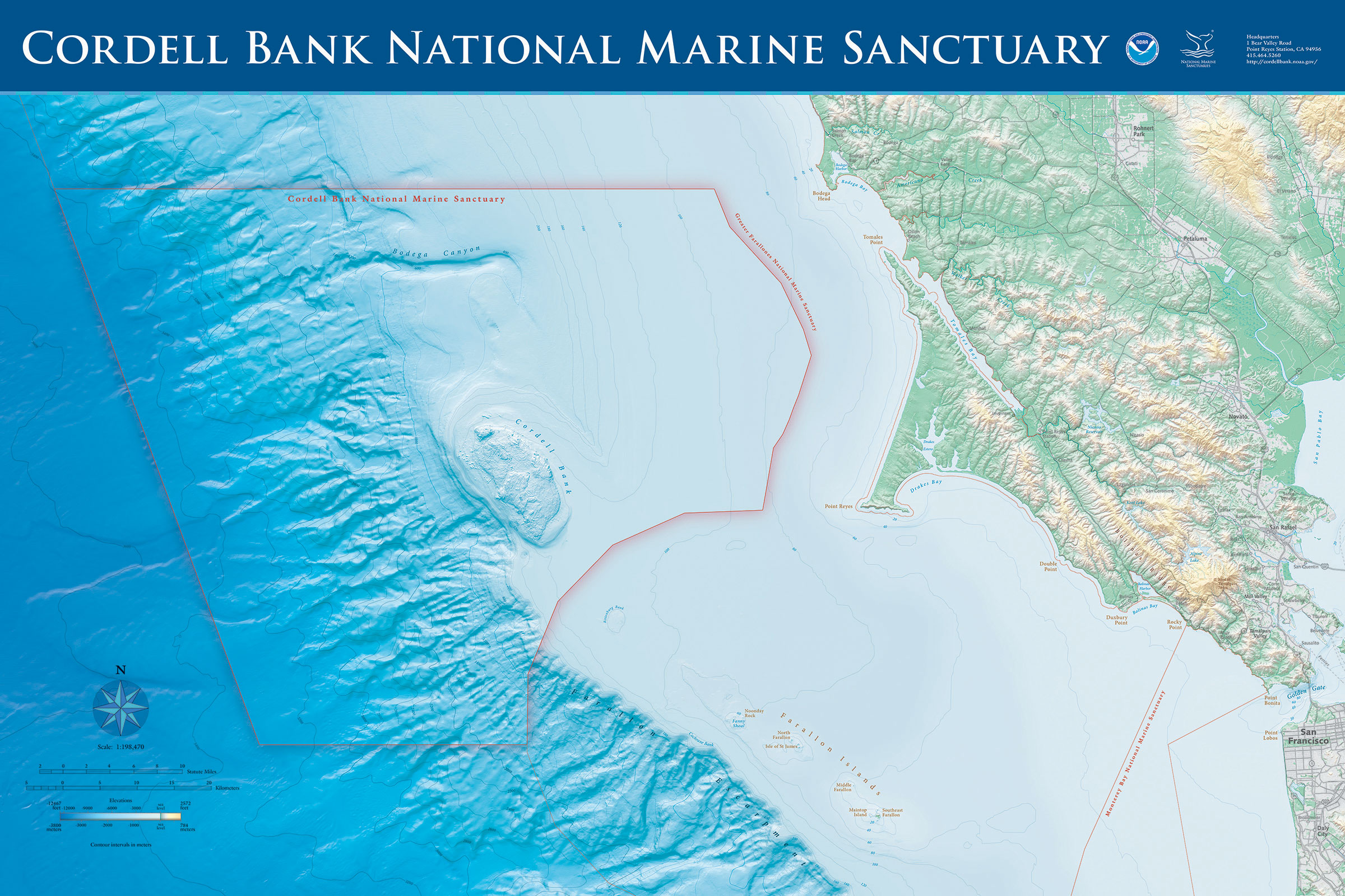
Cordell Bank
Cordell Bank National Marine Sanctuary is an extremely productive marine area off the west coast of United States in northern California. With its southern-most boundary located 42 miles (68 km) north of San Francisco, the sanctuary is entirely offshore, with the eastern boundary six miles...
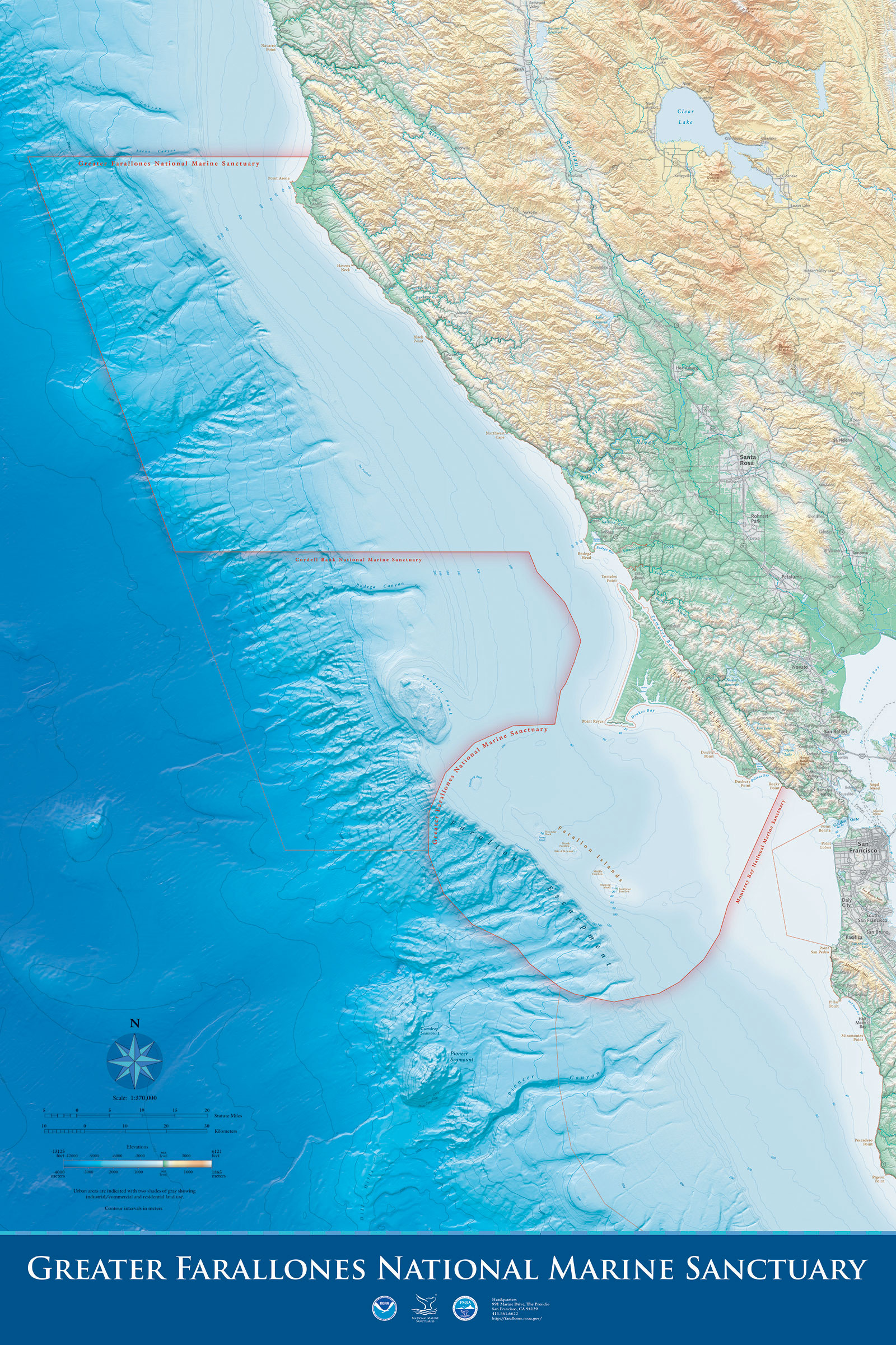
Greater Farallones
Located off the central California coast and encompassing 3,295 square miles, Greater Farallones National Marine Sanctuary protects a diversity of highly productive marine habitats and supports an abundance of species. It is a complex system of bays, estuaries...
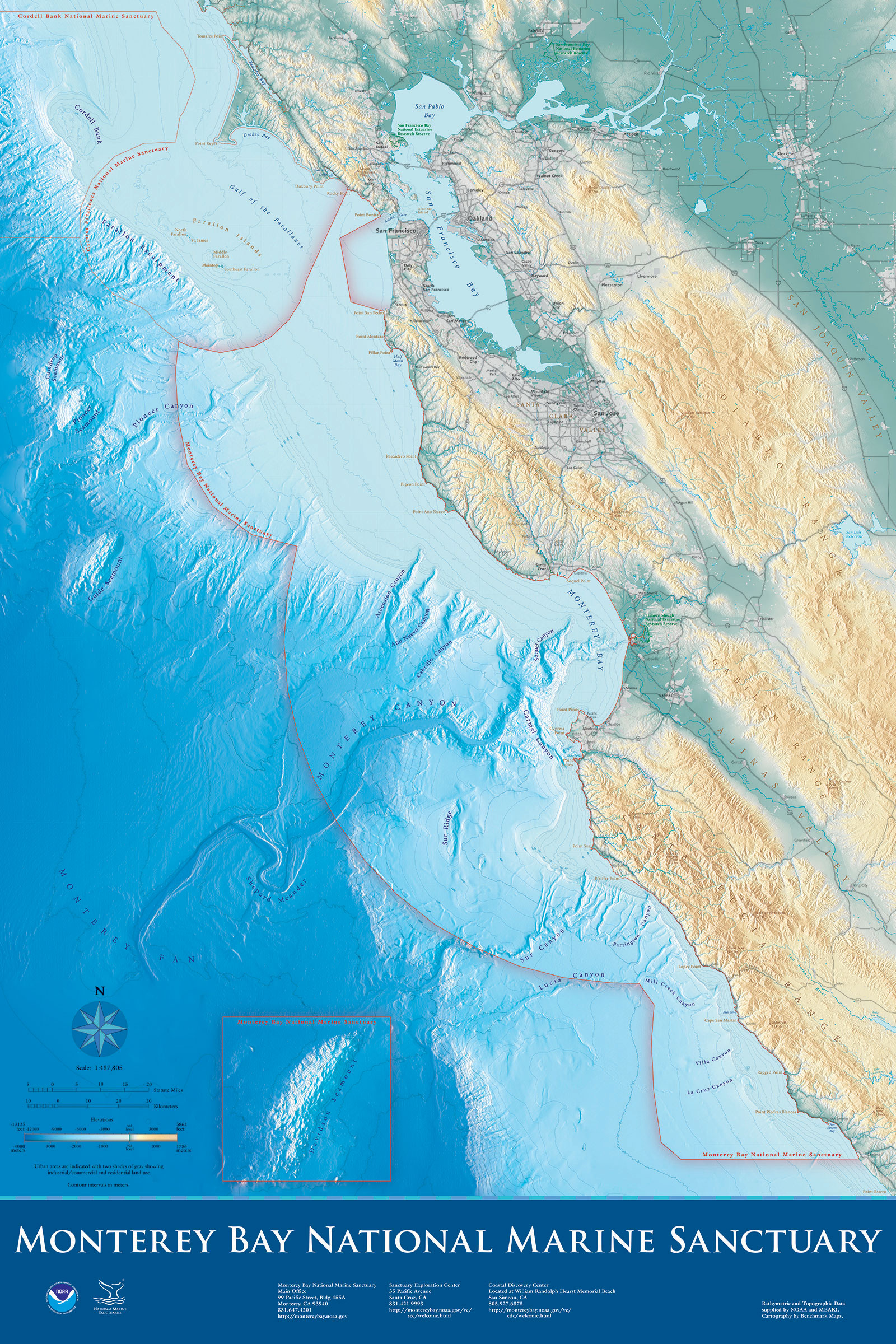
Monterey Bay
Monterey Bay National Marine Sanctuary is the second largest national marine sanctuary and the largest marine protected area in the continental United States. Within the boundaries of the sanctuary is a rich array of habitats...
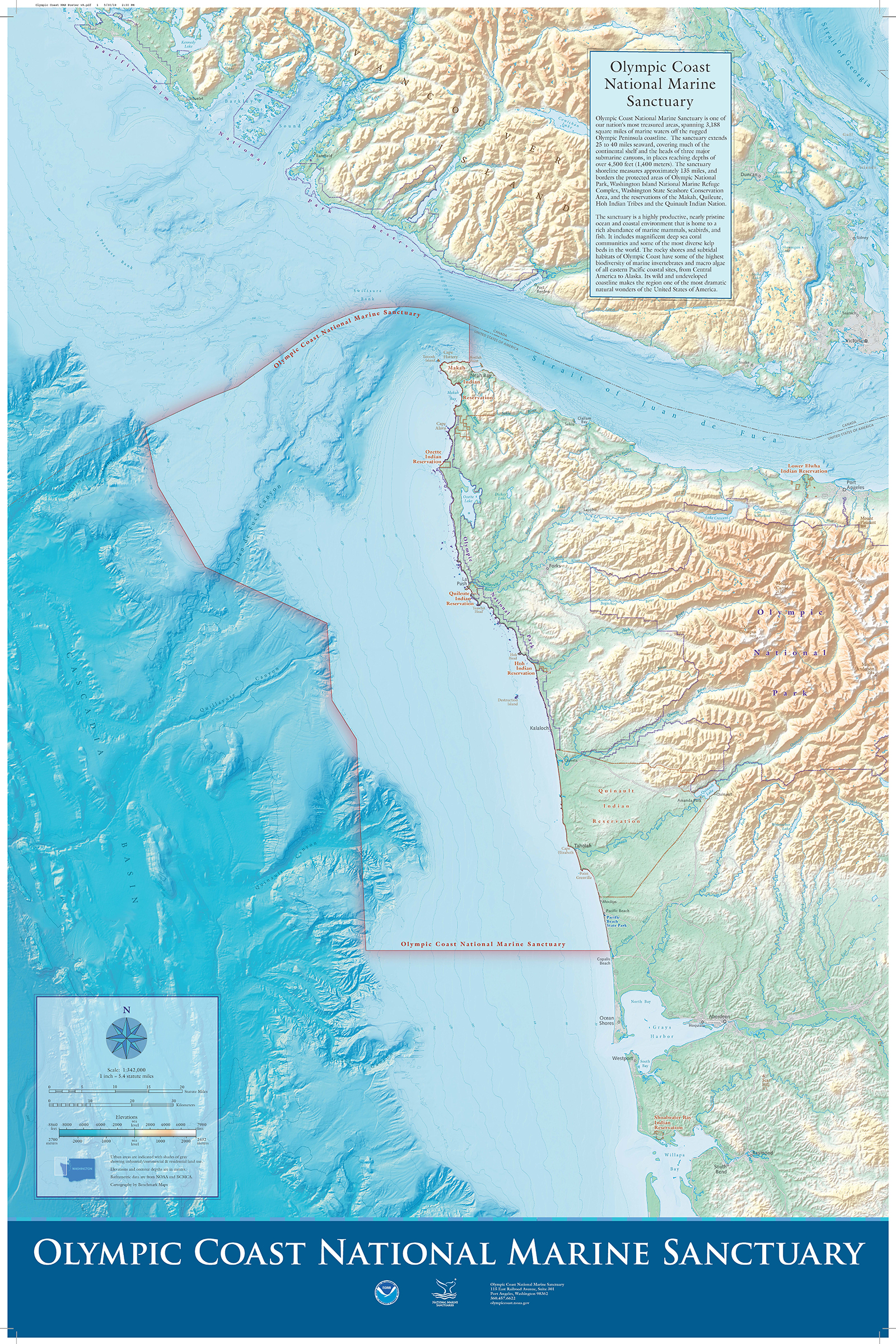
Olympic Coast
Designated in 1994, the sanctuary's mission is to protect the Olympic Coast's natural and cultural resources through responsible stewardship, to conduct and apply research to preserve the area's ecological integrity and maritime heritage, and to promote understanding through public outreach and education...
Resource Protection
Whale Conservation
Several endangered whale species (humpback, blue, and fin) migrate seasonally to west coast national marine sanctuaries where they feed on dense aggregations of krill, northern anchovies, and Pacific sardines. On the U.S. west coast, ship strikes and entanglement in marine debris are the main sources of human-caused mortality for these whales. Research shows that whales have a better chance of avoiding and surviving vessel collisions with vessels travelling at slower speeds. Efforts to minimize the risk of ship strikes by national marine sanctuary staff, in coordination and collaboration with National Marine Fisheries Service staff and affected stakeholders, have been extensive. NOAA, U.S. Coast Guard and Environmental Protection Agency administer a seasonal voluntary vessel speed reduction (VSR) program from May 1 to December 15 requesting all vessels 300 gross tons or larger transit at of 10 knots or less in zones located in southern California and the San Francisco Bay region. Additionally, west coast national marine sanctuary staff administer a successful incentive-based VSR program - known as the Protecting Blue Whales and Blue Skies Program - to further motivate container, bulk and car carrier companies to slow down their fleets in California VSR zones to reduce risk of fatal ship strikes, harmful air emissions and ocean noise. The program, which began in 2014, employs monetary and public relations incentives to raise voluntary cooperation with VSR requests and is administered in collaboration with county air district agencies and foundation partners.
In partnership with the National Marine Fisheries Service Marine Mammal Stranding Network, west coast sanctuary staff also respond to whale entanglement incidents to free whales entangled in various types of debris found discarded in the ocean by humans. Sanctuary staff and vessel crew are trained and ready to support disentanglement of marine mammals.
For more information on whale conservation, visit Channel Islands National Marine Sanctuary’s website.
Seabirds
The five national marine sanctuaries on the west coast are home to the largest concentrations of seabirds in the contiguous United States. Seabirds, including shorebirds, serve as indicators of ocean health within national marine sanctuaries. This is one of several reasons why national marine sanctuaries invest hundreds of thousands of dollars annually to better understand these creatures, protect them and educate the public about them. Recently, we developed a new brochure on seabirds to provide information on the importance of seabirds, research conducted on seabirds and how to reduce human disturbance to seabirds. In addition, Greater Farallones National Marine Sanctuary, in cooperation with Monterey Bay National Marine Sanctuary, have established the California Seabird Protection Network.
Ears in Sanctuaries
Sound and its propagation properties are essential features of the ocean, as nearly all marine life depends on producing and receiving sound to forage, socialize, reproduce, and migrate. Sanctuaries work with many agency, academic, non-profit, and industry partners to characterize "soundscapes", or acoustic communities, in and around sanctuary habitats. Understanding acoustic interactions within an environment involves integrating biological, anthropogenic, climatological, and geological sound sources to holistically describe an ecosystem. West Coast sanctuaries have established baseline understanding of ambient acoustic conditions, species presence and seasonal patterns in both shallow and deep water environments, which is allowing us to better assess the status and trends of protected resources and human activities in these special places. With our nationally coordinated, standardized, continuous monitoring approach, we are also able to describe variability across time and space, glean new understanding of animal behavior, and conduct before-during-after studies of acute acoustic events, such as the covid-19 pandemic or cruise ship visits. The California Current ecosystem along the west coast is a globally important region for both whale populations and a thriving economy. With this in mind, we are using acoustic information to support management actions and multi-sector partnerships to safeguard whales and a sustainable blue economy. For example, the West Coast Region is dedicated to reducing ship strike risk, air pollution emissions, and vessel noise inputs by slowing large ships transiting through sanctuaries. All of the sound data collected in sanctuaries is open access and archived at NOAA's National Center for Environmental Information. Users can learn more about studying ocean sound in sanctuaries, our data collection efforts, ongoing analysis approaches, browse a sound clip library, and interact with our data using our web portal. Please visit the ONMS Ocean Sound and Impact of Noise Resource Collection for educational resources.
Education and Outreach
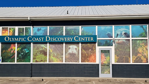
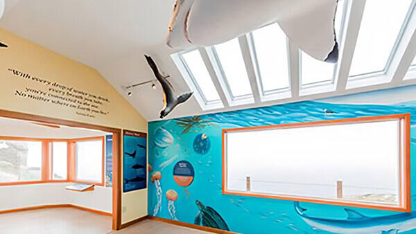
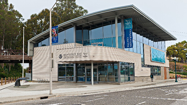
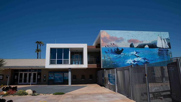
Visitor Centers and Exhibits
Visiting one of the sanctuary visitor centers along the west coast is a great way to learn more about the natural and cultural treasures protected by sanctuaries. Experience hands-on exhibits, participate in educational programs and investigate the science and history of these special places.
West Coast Field Guide and Travel Writer Brochure
The West Coast Field Guide introduces you to the natural and cultural wonders of your national marine sanctuaries. The California current, many marine species and historic ocean uses all connect these sanctuaries to each other, and to the human communities on the west coast. You can view an electronic version of the field guide online or have a free copy hard copy mailed to you by emailing nicole.capps@noaa.gov.
To further tourism within the west coast national marine sanctuaries, a Travel Writer Brochure has been developed and is available for download only.
Wildlife Viewing
The west coast sanctuaries are renowned for their abundance of wildlife and it is important we know how to properly interact with that wildlife. Please visit the Wildlife Viewing website for general marine wildlife viewing guidelines that help promote safe wildlife viewing. Take the wildlife pledge to be a responsible wildlife watcher!
LiMPETS
LiMPETS (Long-term Monitoring Program and Experiential Training for Students) is an environmental monitoring and education program for students, educators and volunteer groups throughout California. As part of this network, teachers and students collect rocky intertidal and sandy beach data.
Research
Changing Ocean Conditions in the West Coast Region
The impacts of changing ocean conditions are intensifying both globally and locally, presenting new challenges to America’s physical, social, economic, and environmental well-being. West coast national marine sanctuaries must contend with rising water temperatures and sea levels, water that is more acidic and contains less oxygen, shifting species, and altered weather patterns and storms. In April 2021, these impacts were detailed for the West Coast Region in a report highlighting regional changes in ocean conditions and subsequent challenges, as well as opportunities for collaboration. Information contained in the report reflects the state of the science as of the date of publication (April 2021). Our understanding of changing ocean conditions and the associated challenges can change as new science is conducted. This profile will be updated periodically as scientific understanding changes. In an effort to respond to one particular challenge, the West Coast Regional Office published the National Marine Sanctuaries of the West Coast Ocean Acidification Action Plan. This plan was produced in response to the five west coast Sanctuary Advisory Council resolutions calling for some form of action on the topic of ocean acidification. Following a workshop of 90 participants, the National NOAA Ocean Acidification Education Implementation Plan was developed to help the public understand the complex issues arising from changes in ocean chemistry in response to ocean acidification.
Sanctuary Integrated Monitoring Network
Comprehensive, long-term monitoring is a fundamental element of resource management and protection. Monterey Bay National Marine Sanctuary's Research Program monitors ecosystem resources through SIMoN, the Sanctuary Integrated Monitoring Network. SIMoN, now expanded to Greater Farallones and Cordell Bank national marine sanctuaries, is an integrated, long-term program that takes an ecosystem approach to identify and understand changes in each sanctuary. It provides resource managers with the information needed for effective decision-making and integrates ongoing efforts at the over 30 regional marine research institutions.
Maritime Heritage
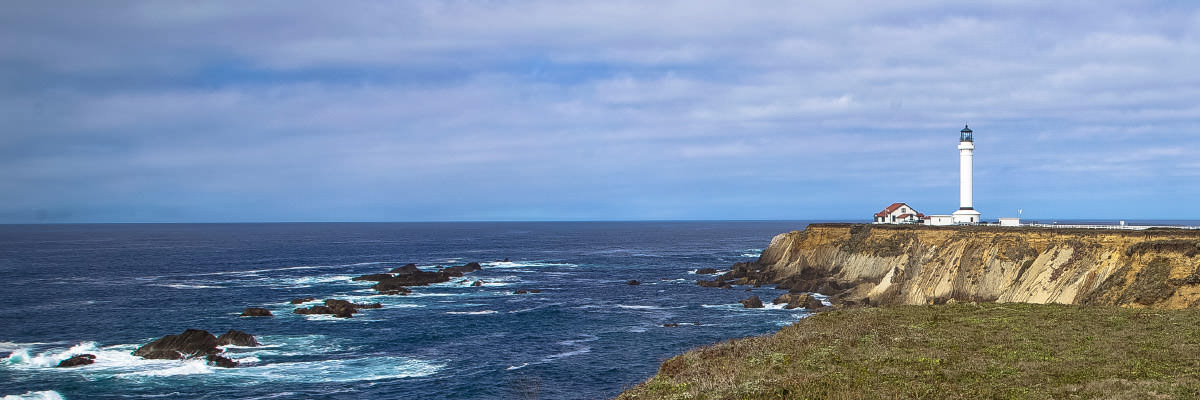
The West Coast Region seeks to support research into human connections to the sea that include indigenous native cultures, seafaring traditions and the discovery and protection of maritime heritage resources. Today, indigenous people continue their seafaring cultural activities that include building traditional watercraft and traversing sanctuary waters. Maritime heritage resources such as shipwrecks, and those objects which remain in place to remind us of historic activities such as lighthouses, historic wharves, docks and piers, populate the coastline from the State of Washington to California. Please visit the West Coast Region's maritime heritage webpage for more information.
WCRO Contact Information
Sarah Fangman, Regional Director
Paul Michel, Regional Policy Coordinator
Laura Ingulsrud, Regional Policy Analyst
Dave Lott, Regional Operations Coordinator
Josh Gunn, Regional Vessel Operations Coordinator
Nicole Capps, Management Support Specialist
Nishan Perera, Regional IT Specialist
LTJG Ryan Tyler, NOAA Corps
Office of National Marine Sanctuaries
West Coast Regional Office
99 Pacific Street, Bldg. 100, Suite F
Monterey, CA 93940
(831) 647-1920
Maps
West Coast Region

Chumash Heritage National Marine Sanctuary
