Greater Farallones National Marine Sanctuary
Condition Report 2010–2022

Executive Summary
Greater Farallones National Marine Sanctuary (GFNMS) was designated in 1981 and expanded to its current size of 3,295 square miles in 2015. GFNMS is located off the California coast, extending west of southern Mendocino, Sonoma, Marin, San Francisco, and San Mateo counties. The sanctuary extends from the mean high tide line, with exceptions, to the continental margin at or about the 10,000-foot depth contour. The sanctuary is adjacent to Cordell Bank National Marine Sanctuary (CBNMS), sharing CBNMS’s northern and eastern boundaries, and Monterey Bay National Marine Sanctuary (MBNMS), sharing MBNMS’s northern boundary. GFNMS includes Estero Americano, Estero de San Antonio, Tomales Bay, and Bolinas Lagoon, as well as the waters surrounding the Farallon Islands.
This condition report uses the best available information to assess the status and trends of the sanctuary’s resources and ecosystem services from 2010 to 2022. The report, structured around a Drivers-Pressures-State-Ecosystem Services-Response model, covers water quality, habitat, living resources, and maritime heritage resources, and also includes the first evaluation of the status and trends of ecosystem services—the ways humans derive benefits from different ecosystem attributes that they care about for their lives, lifestyles, and livelihoods.
Pressures on the Sanctuary
The primary pressures identified for GFNMS were climate change, land use, marine harvest activities, vessel activity, marine debris, wildlife disturbance, and non-indigenous species. Below is a summary of the primary pressures and the status of these pressures in the sanctuary.
Climate change affects all aspects of the sanctuary, including, but not limited to, water quality, species abundance and distribution, human activities, and ecosystem services. The climate-related pressures of greatest concern are rising ocean temperatures, marine heatwaves, habitat compression, and ocean acidification, as well as sea level rise and changes in storm frequency and intensity, which can cause secondary pressures such as changes to shorelines and sediment transport. The marine heatwave in 2014–2016 was a significant event that resulted in unprecedented ecological and economic impacts in the region.

Land use activities adjacent to the sanctuary, such as agriculture, transportation, urbanization, and construction create pollutants, including sediments, plastics, and chemicals that impact water quality, marine species, and habitats. In addition, artificial structures that harden or stabilize shorelines in and around Bolinas Lagoon and Tomales Bay (such as seawalls, rip rap, roadways, etc.) can reduce habitat quality and availability, as well as reduce natural buffering capacity, but are fairly minimal in the sanctuary. Historic mercury mining led to the impairment of Tomales Bay and connected watersheds.
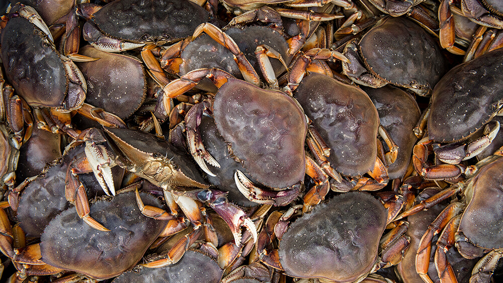
Commercial and recreational fishing in GFNMS contribute to the local economy and culture, support jobs, and provide food, but also impact sanctuary habitats and species through harvest, bycatch, seafloor impacts, lost gear, and wildlife entanglement. Entanglement of humpback whales in Dungeness crab gear, as well as other types of debris, is a concern in GFNMS. Aquaculture operations in Tomales Bay produce marine debris and alter habitat through infrastructure installations on the seafloor.

Vessel impacts include damage to seafloor habitat from anchoring or grounded or sunken vessels; discharge of oil and sewage and debris in the water; air and water pollution via exhaust gas emissions; and noise pollution. Although no major vessel oil spill events occurred in the sanctuary during the study period, small oil discharges did occur, and cruise ships discharged large amounts of untreated black and gray water, membrane bioreactor sludge, exhaust gas cleaning system effluent, and food waste. Unpermitted vessel moorings have been removed from Tomales Bay, which appears to have allowed eelgrass beds to recover. In addition to impacts on habitat, vessels may also directly affect living resources; vessel strikes to whales can lead to injury or death of the whale and are a concern in GFNMS.
Marine debris enters the sanctuary from both water and land-based activities, accumulates in the water column and benthic habitats, and also poses a risk of ingestion by wildlife. Marine debris of many varieties has been observed in all habitats in the sanctuary, and has entangled wildlife and damaged sensitive habitats and species. Lost fishing gear is the most common type of debris observed in benthic habitat.

Wildlife disturbance includes trampling sensitive intertidal species and close approaches from humans, dogs, boats, aircraft, and uncrewed aerial systems, which disturb seabirds and marine mammals. Birds were disturbed primarily by low-flying aircraft, and harbor seals were disturbed by humans, motorboats, and other sources; however, these disturbances did not appear to impact population sizes of harbor seals or seabirds or their use of the sanctuary. Overall levels of wildlife disturbance in recent years were lower compared to the previous decade.
Non-indigenous species in the marine and estuarine environment can alter species composition, threaten the abundance and diversity of native marine species, interfere with ecosystem function and disrupt fisheries. Non-indigenous species are present in GFNMS coastal and offshore and estuarine and lagoon habitats.
Status and Trends of Sanctuary Resources
In addition to describing pressures on the sanctuary, the condition report rates the status and trends of water quality, habitat, living resources, maritime heritage resources, and ecosystem services in GFNMS. Coastal and offshore environments were evaluated separately from estuarine and lagoon environments in the report. Representative data indicators were selected for each section that would be informative of the status and trend of conditions in the sanctuary. Criteria for data indicator selection included: long-term data availability, importance to the ecosystem and culture, responsiveness to changes in environmental conditions, measurability, relevance to sanctuary condition report questions, and responsiveness to management actions. The section below summarizes the most noteworthy results.
Water Quality
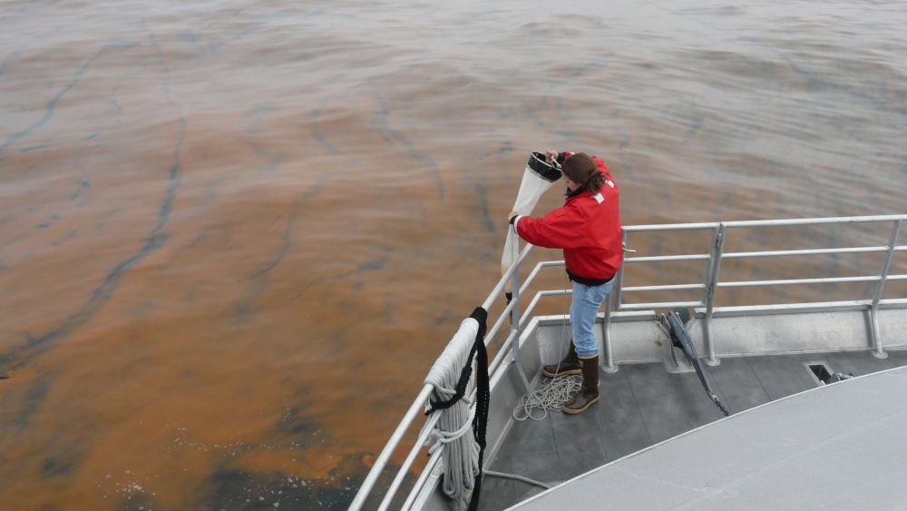
Climate change has affected water quality in the coastal and offshore environment of GFNMS. In the offshore environment, marine heatwaves in 2014–2016 and 2019 were correlated with harmful algal blooms and habitat compression. There were also more instances of unusually high sea surface temperature during the study period, and ocean acidification was evident at deeper offshore depths. Eutrophication (excessive algae growth resulting from increased nutrient input) was not present in the offshore environment.
Water quality in the estuarine and lagoon environment was impacted by climate stressors such as increased sea surface temperatures, as well as a decline in precipitation and associated increase in salinity. In Tomales Bay, there was an overall decrease in corrosive conditions for shell forming species over the study period, but corrosive conditions were present during the winters.
Water quality issues also posed a risk to human health in both the coastal and offshore and estuarine and lagoon environments. In coastal and offshore environments, levels of toxins exceeding regulatory thresholds were present. The biotoxin saxitoxin, which causes paralytic shellfish poisoning, exceeded regulatory thresholds in offshore shellfish samples in most years. The Dungeness crab fishery experienced temporary closures due to domoic acid in 2015–2018. Beach advisories for water contact due to elevated pathogenic bacteria were issued for some beaches in Sonoma and Marin counties.
In estuaries, advisories were in place to limit consumption of some fish species from Tomales Bay due to mercury contamination, saxitoxin concentrations exceeded the regulatory threshold in 2013, 2014, 2017, 2018, and 2019, and shellfishery closures occurred every year due to rainfall, saxitoxin, Vibrio, or norovirus. Tomales Bay was listed as an impaired body under Section 303(d) of the Clean Water Act due to sedimentation/siltation, nutrients, mercury, and pathogens, while Estero Americano and Estero de San Antonio were listed as impaired due to nutrients and sedimentation. Beaches in Tomales Bay had beach advisories due to elevated levels of fecal coliform bacteria on 131 occasions from 2010–2021. Other water quality concerns in the sanctuary included microplastic pollution and vessel discharges, however there were limited data available to evaluate the status and trends and assess the impacts to the sanctuary from these stressors. Most water quality parameters are measured by partners.
Habitat
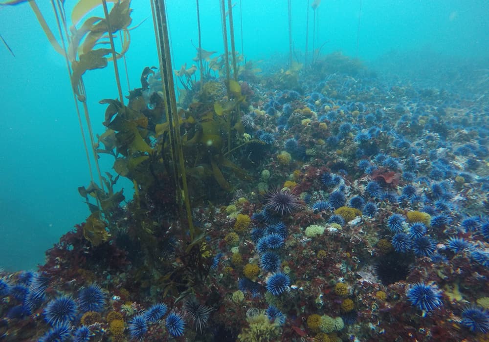
In the coastal and offshore environment, kelp habitat decreased by over 90% since 2014 and has not recovered. Rocky intertidal habitat was stable based on the percent cover or abundance of key habitat-forming species. Levels of shoreline armoring remained low at 2% of shoreline armored, with no new armoring added during the study period. The majority of beaches in GFNMS are experiencing erosion that threatens beach and dune ecosystems, but more information is needed to assess the trends in sediment dynamics. In deep-sea habitats that were explored in GFNMS, diverse communities of corals, sponges, other invertebrates, and fish were observed. However, only a small portion of this habitat has been explored, and more information is needed to be able to fully characterize this habitat and track trends. There is concern about impacts to benthic habitat from active and lost fishing gear and derelict or sunken vessels, but more information is needed to fully characterize the impacts.

In the estuarine and lagoon environment, there were no losses to marsh and mudflat habitat during the study period, although the amount of this habitat had been reduced from historic levels. Restoration projects have improved water quality and circulation and allowed native vegetation to increase, but more data are needed to determine the trend. The extent of eelgrass habitat in Tomales Bay appears to be increasing as a result of removing unpermitted moorings from eelgrass beds, but continued monitoring is needed to fully understand the trend, and additional measurements are needed to better understand the health and ecosystem function of the eelgrass beds.
Contaminants were documented in sanctuary habitats. In the offshore environment, mercury was present in sediment samples collected offshore from Stinson Beach, and levels significantly increased over time during the study period, but remained below the threshold for negative effects to marine organisms. Multiple contaminants in Dungeness crab were below regulatory thresholds, except for mercury in 2010 and PCBs in 2015. Tarballs were present on coastal beaches; although not definitive, tests showed that these tarballs likely came from natural seeps. There were no major oil spills during the study period. Mercury is present in Tomales Bay due to historic mining. After remediation in 1999–2000, mercury was still present, but had decreased in the bay’s sediment.
Living Resources
In the coastal and offshore environment, sea stars were decimated by sea star wasting disease. This resulted in an increase in their prey, purple urchins, which extensively fed on kelp and contributed to bull kelp loss and lack of recovery. Although the abundance of prey species naturally fluctuates, in recent years, there was a notable increase in anchovy and decline in krill, and, following peaks in abundance, decreases in juvenile rockfish in the offshore environment. White sharks were abundant and were estimated to be increasing.
Densities of humpback whales increased in the sanctuary during the study period, but the status of humpback whales is a concern because they face several threats in and around GFNMS, including ship strikes, entanglements, and climate-related changes in forage species and habitat compression. Habitat compression, when cool, upwelled water is restricted to the coast instead of across the continental shelf, affects forage species distribution and abundance, which subsequently increases the overlap of whales and human activities, such as shipping and fishing, making whales more vulnerable to ship strikes and entanglement.
Seabird abundances at the South Farallon Islands remained stable or increased over the past couple of decades, while shorebird presence along the mainland remained stable or decreased.

Rocky intertidal species showed variability over time, but overall species abundances or percent cover remained stable or increased once the 2014–2016 marine heatwave subsided, with the exception of northern rockweed, which decreased.
In the estuarine and lagoon environment, native Olympia oysters are present. Although their population size was unknown for this study period, it was thought to be low. Shorebird encounter rates declined in the sanctuary, consistent with declines in global populations of shorebirds. The encounter rates of brant, a small sea goose, were variable in the past several decades and were at the low end of the range in recent years.
Eighty-four non-indigenous species have been documented in the sanctuary. The most notable species are the European green crab and the Japanese mud snail; both species can have measurable impacts but are currently restricted to specific locations in estuarine and lagoon habitat.
Overall, biodiversity in the sanctuary was within the expected range of long-term natural variability, although data in the estuarine and lagoon environment was insufficient to assess this component. Shifts in species distribution resulting from the 2014–2016 marine heatwave may have affected the biodiversity of the sanctuary in both positive and negative ways.
Maritime Heritage Resources
Shipwrecks and doghole ports are the primary documented tangible maritime heritage resources in the coastal and offshore environment of GFNMS. Of the records of hundreds of possible shipwrecks in the sanctuary, only a small fraction have been confirmed and documented, and 14 of the 24 doghole ports have been documented. Although these sites are not monitored, human impacts to resources were thought to be minimal, with natural degradation as the primary threat. Further exploration and assessment could reveal additional historical resources in GFNMS.
Status and Trends of Ecosystem Services
Ecosystem services evaluated in the report included science, education, heritage, sense of place, consumptive recreation, non-consumptive recreation, commercial harvest, and coastal protection.
GFNMS has several long-term monitoring projects that have provided critical scientific information to inform the sanctuary and guide management actions. Through work on these projects, staff have developed partnerships with many agency, non-profit, and academic scientists, and the science findings have been shared through presentations, reports, and articles. However, research and monitoring is minimal in some habitats, such as estuarine and lagoon and deep-sea habitats, and there are significant challenges to accessing some portions of the sanctuary due to weather, hazardous diving conditions, and limited vessel capabilities, which limited the capacity to conduct research in these areas.

The education program of GFNMS has a diverse repertoire of offerings to reach students and teachers in formal classroom settings, as well as informal education and outreach to general audiences. The demand for sanctuary school education programs exceeded the capacity of GFNMS staff, facilities, and funding, limiting the ability to reach new audiences and engage the diverse communities of the San Francisco Bay Area in sanctuary education.
Hundreds to thousands of years of maritime and coastal history contribute to the rich heritage of the GFNMS region, and the sanctuary supports the heritage ecosystem service through protection of historic shipwrecks and places, interpretation through exhibits and programs, and partnerships with regional museums and organizations. As a result of the sanctuary expansion north along Sonoma County and into Mendocino County and increased recognition of the important maritime heritage resources in the expanded boundaries, the ability to support this service has improved, but more information, collaboration, and partnership is needed. There is a need to identify and characterize iconic heritage locations and locate and assess shipwrecks so that the sanctuary can protect these special places.
The sanctuary’s long shoreline and proximity to a major metropolitan area provides access points to connect many communities in north-central California to the sanctuary. GFNMS cultivates this community connection and sense of place through media (film, video, and photograph), field trips, and volunteer opportunities.
Sanctuary habitats provide opportunities for non-consumptive recreation, including wildlife viewing, board sports, kayaking, diving, beachgoing, and tidepooling. The productive ocean ecosystem in GFNMS has supported wildlife viewing businesses, with some increase in demand observed. Engagement in recreational activities like surfing, stand-up paddle boarding, and wildlife watching from shore and from vessels appear to have increased in GFNMS.
The waters of the sanctuary provide the ecosystem service of commercial and recreational consumptive harvest. Fisheries in the region are considered abundant and diverse, with Dungeness crab, salmon, and groundfish commonly targeted for both commercial and recreational fisheries, along with other species. Recent changes in ocean temperature and extensive harmful algal blooms have impacted fisheries, causing crab fishery opening delays and closures to mitigate harmful algal bloom exposure and fishing gear entanglement risk to whales, and contributed to the loss of kelp, resulting in the collapse of the red abalone sport fishery.

Climate-change-related impacts, such as extreme storm events, rising sea levels, marine heatwaves, ocean acidification, and increased erosion, negatively impact livelihoods dependent on a healthy ocean environment, such as commercial fishing, recreational operations, and tourism economies. Additionally, these impacts can affect shoreline stability and access for coastal communities and participation in recreational activities such as diving, beach combing, and tidepooling, compromising the sanctuary’s capacity to provide these ecosystem services.
Response to Pressures
Since the last condition report, the sanctuary has responded to pressures by developing more robust, new, and extensive monitoring projects to better understand impacts and measure management effectiveness. Since 2015, shoreline monitoring has been extended north into Mendocino County to understand human uses, wildlife presence, and identify potential threats to the sanctuary. Offshore monitoring has been opportunistically extended north off of Sonoma County when NOAA ships are available to monitor vessel traffic, wildlife, water quality, and threats. The data collected from sanctuary and partner monitoring projects have been used by GFNMS’s Seabird Protection Network project to address seabird disturbance from vessels. As a result, a decrease in vessel disturbance has been observed at breeding seabird colonies. After GFNMS clarified NOAA low overflight zone regulations and initiated a pilot engagement project, recorded disturbance to seabirds from low-flying aircraft decreased. Since 2010, GFNMS has been working to reduce ship strikes to whales in the sanctuary. After implementing seasonal voluntary vessel speed reduction throughout the sanctuary and sending letters to the shipping industry, GFNMS observed 61% of all the vessels 300 gross tons or larger traveling at speeds of 10 knots or less in 2022 resulting in an approximate 25% reduction in risk in lethal ship strikes to endangered blue whales and endangered and threatened humpback whales, compared to 2015 transits, in the sanctuary. The sanctuary has observed eelgrass returning to sites where unpermitted moorings were removed in Tomales Bay. Data collected by the sanctuary to characterize deep sea coral and sponge habitat has been provided to the Pacific Fisheries Management Council and used by the council to develop fisheries policies that reduce impacts to sanctuary benthic habitat.

Recognizing that climate change had the potential to be the biggest threat to the health of the sanctuary, the sanctuary developed a systematic approach to understanding and addressing climate impacts. A climate impact report was developed with the guidance of the Sanctuary Advisory Council to document observed and predicted climate impacts to the sanctuary. The advisory council used the climate impacts report to advise the sanctuary on biological and physical climate change indicators to monitor. Building off the two reports, the sanctuary conducted an expert-guided climate vulnerability assessment to identify the most vulnerable species, habitats, and ecosystem services in the sanctuary. The climate vulnerability assessment was used by the advisory council to provide a suite of recommended actions to GFNMS, which were then used as a foundation for the sanctuary’s climate adaptation plan, which describes strategies and actions to address the greatest climate threats in the sanctuary. GFNMS has been implementing the strategies in the adaptation plan, including prioritizing whale and deep-sea coral protection, restoring coastal habitats that sequester carbon, investigating offshore habitats that sequester carbon, and working with Bay Area agencies to develop coastal resilience strategies.
To ensure the current and next generation of ocean stewards are aware of the sanctuary, understand its ecological importance and importance to a healthy Bay Area community, and engage in active participation with the sanctuary, GFNMS delivered targeted education projects that have supported a sense of place and engagement in conservation. Education and outreach efforts included formal (e.g., teacher workshops and student field trips) and informal (e.g., exhibits and lectures) efforts. Efforts to share the heritage of the sanctuary were done through sharing information about historic places and ships in the sanctuary, participating in heritage-related community events, and partnering with museums and parks on exhibits.
Conclusion
In summary, from 2010–2022, GFNMS has focused on reducing human-caused pressures that have threatened sanctuary resources. GFNMS has made significant contributions that are responsive to known or emerging pressures, including direct interventions by sanctuary managers or actions resulting from GFNMS-led partnerships. Recommendations for future actions are not included in the condition report; however, information is provided on potential future needs to address pressures that need attention and responses that may need to continue. This condition report will support the development of a new management plan, and its findings will serve as an important foundation to help GFNMS set future priorities based on known needs and ensure current management and regulatory responses are adequate. GFNMS staff will be fully evaluating the data gaps and information needs highlighted in this report to ensure the next management plan addresses the highest priority topics and management actions.
